Log in
All resources
Create a design
514 Free Images of Round Maps
computer
knight
soldier
game
archery
unit
videogame
tileset
tower
blue
building
maps
building
maps
building
maps
building
maps
building
maps
building
maps
building
maps
building
maps
christmas
maps
christmas
maps
2010 photos by jim.henderson
pages with maps
pd-art (pd-old-auto)
cc-pd-mark
building
maps
christmas
maps
agriculture
grass
agriculture
grass
background
maps
round table
light
john rocque's 1748 map of london and adjacent country
bibliothèque nationale de france
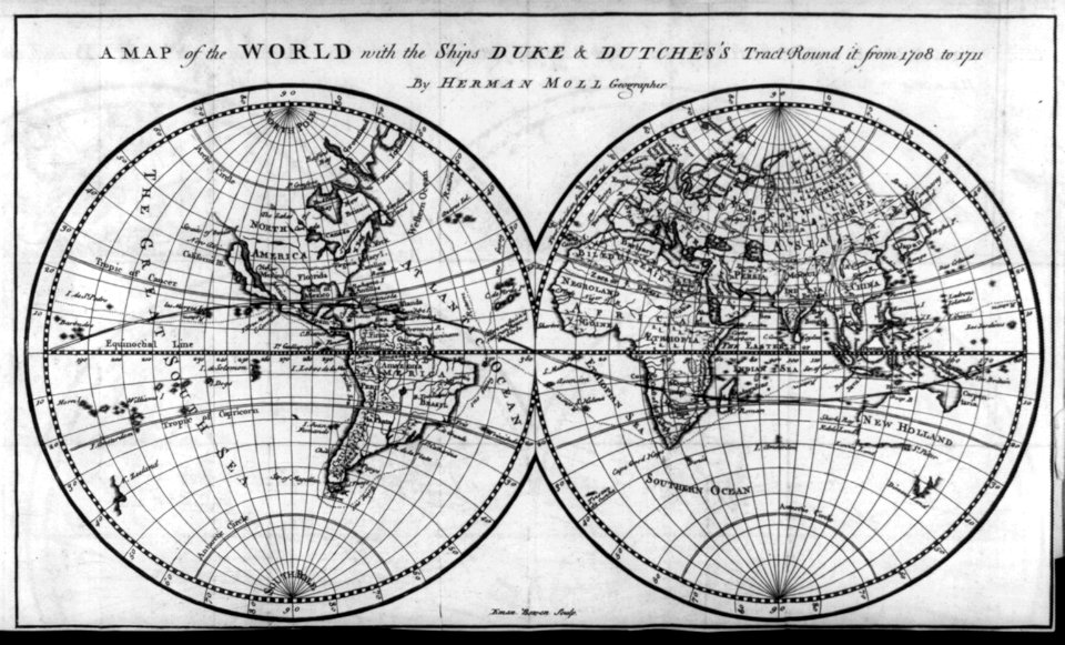
maps of circumnavigations of the world
1740s maps of the world
john rocque's 1748 map of london and adjacent country
maps in the british museum
meeting the sun - a journey all round the world (1874)
maps of the temple of heaven
maps of novaya zemlya
1590s maps
très riches heures du duc de berry
early netherlandish painting
historical
history
meeting the sun - a journey all round the world (1874)
plans of the forbidden city
ionicons pack
round
material pack
maps
marker
round
john rocque's 1748 map of london and adjacent country
remigius parr
building
castle
john rocque's 1748 map of london and adjacent country
remigius parr
map pack
square
material pack
maps
john rocque's 1748 map of london and adjacent country
remigius parr
maps
zoom
maps in the library of congress
1777 maps of boston
maps of battles of france
1744 maps
1823 maps of new york city
circular maps
evericons pack
maps
building
flag
maps of the arctic by gerardus mercator
maps by hendrik hondius the younger
water
green
maps in the rijksmuseum amsterdam
old maps of the ottoman empire
maps of paris by john rocque
plan de roussel
maps of paris by john rocque
plan de roussel
orange pack
geotagged
circle
maps
kameleon free pack - rounded pack
application
orange round pack
orange
historical
history
planet
maps
john rocque's 1748 map of london and adjacent country
bibliothèque nationale de france
john rocque's 1748 map of london and adjacent country
bibliothèque nationale de france
john rocque's 1748 map of london and adjacent country
bibliothèque nationale de france
john rocque's 1748 map of london and adjacent country
bibliothèque nationale de france
john rocque's 1748 map of london and adjacent country
bibliothèque nationale de france
john rocque's 1748 map of london and adjacent country
bibliothèque nationale de france
prints, drawings and watercolours of the royal museums greenwich
william henry toms
computer
maps
computer
maps
computer
maps
computer
maps
computer
maps
historical
history
computer
maps
computer
maps
computer
maps
computer
maps
computer
maps
computer
maps
computer
maps
swords
maps
computer
maps
computer
maps
computer
maps
computer
maps
swords
maps
swords
maps
computer
maps
swords
maps
computer
maps
planet
earth
map pointers
svg dots
round icons
dotset 1
self-published work
round svg icons
map pointers
round icons
prints by james gillray in the british museum
satirical prints in the british museum
self-published work
map pointers
self-published work
round svg icons
map pointers
dotset 1
map pointers
dotset 1
map pointers
dotset 1
pink icons
dotset 1
historical
history
map pointers
round icons
earth
maps
self-published work
map pointers
yellow button
dotset 1
background
maps
401 - 500 of 514
Next page
/ 6


![The Jersey smuggler detected; - or - good causes for discontent [separation], James Gillray, 1796](https://cdn.creazilla.com/illustrations/10000249640/the-jersey-smuggler-detected-or-good-causes-for-discontent-separation-james-gillray-1796-md.jpg)